
|
Banks Lake Vacation Rentals
|

|
|
|
|
|
Banks Lake Hotels and Resorts
|
|
|
| | | Hotels & Motels |
| Ephrata Travelodge | 31 Basin St SW | Ephrata, WA | 23.7 mi. | (509) 754-4651 |

|
Banks Lake Weather & Climate
|

|
|
|
Central Washington , near the Columbia River Plateau, snow can be expected after the first of December and average from 10 to 35 inches. The Central Basin is subject to "chinook" winds which produce a rapid rise in temperature. A few damaging hailstorms are reported each summer. The average January maximum temperature is 30� F in the colder localities in the Columbia Basin. In July the average maximum temperature is in the lower 90's, and the minimum temperature is in the upper 50's. Maximum temperatures reach 100� to 105� on a few afternoons each summer. The last freezing temperature n the spring occurs during the latter half of May in the colder localities of the Columbia Basin. The first freezing temperature in the fall is usually recorded between mid-September and mid-October.
|
| Month |
High Temp |
Low Temp |
Rainfall |
Ocean Temp |
| January |
33°F |
19°F |
0.83 in. |
- |
| February |
40°F |
24°F |
0.97 in. |
- |
| March |
51°F |
30°F |
0.99 in. |
- |
| April |
62°F |
35°F |
0.77 in. |
- |
| May |
71°F |
42°F |
1.06 in. |
- |
| June |
78°F |
48°F |
0.81 in. |
- |
| July |
87°F |
55°F |
0.69 in. |
- |
| August |
86°F |
55°F |
0.46 in. |
- |
| September |
77°F |
47°F |
0.50 in. |
- |
| October |
62°F |
36°F |
0.59 in. |
- |
| November |
43°F |
27°F |
1.37 in. |
- |
| December |
33°F |
20°F |
1.41 in. |
- |

|
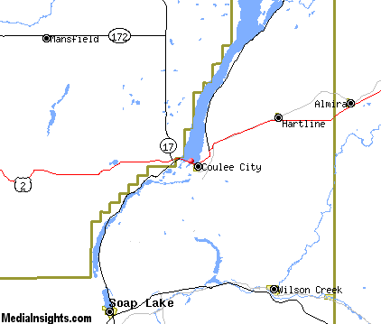
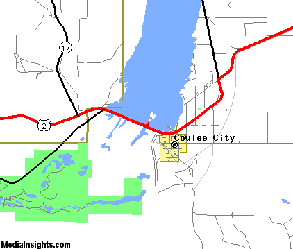
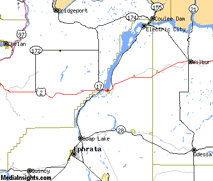
Banks Lake Map & Transportation
|

|
|
 |
|
|
| Click each thumbnail image to enlarge. |
 |
|
 |
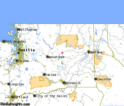 |
The closest airports in the area are the Ephrata Municipal airport (EPH) located about 23 miles southwest of Banks Lake in Ephrata, Washington, the Grant County International airport (MWH) located approximately 28 miles south of Banks Lake in Moses Lake, Washington, the Pangborn Memorial airport (EAT) located roughly 44 miles west of Banks Lake in Wenatchee, Washington, and finally Bowers Field (ELN) located around 70 miles southwest of Banks Lake in Ellensburg, Washington.
|

|
Banks Lake Attractions
|

|
|
| | | Amusement and Theme Parks |
| Riverfront Park | Spokane | WA | 87.6 mi. | |
| | | Golf Courses |
| Vic Meyers Golf Course | Coulee City | WA | 1.0 mi. | | | Oasis Park Golf Course | Ephrata | WA | 24.3 mi. | | | Banks Lake Golf & Country Club | Electric City | WA | 25.0 mi. | | | Big Bend Golf & Country Club | Wilbur | WA | 29.6 mi. | |
| | | Ski Areas |
| Mission Ridge | Wenatchee | WA | 48.7 mi. | |
| | | State Parks |
| Sun Lakes State Park | | WA | 3.3 mi. | | | Summer Falls State Park | | WA | 8.4 mi. | | | Sunlake State Park | | WA | 14.6 mi. | | | Steamboat Rock State Park | | WA | 18.5 mi. | | | Northrup Canyon State Park | | WA | 21.0 mi. | | | Crown Point State Park | | WA | 28.5 mi. | | | Bridgeport State Park | | WA | 30.2 mi. | | | Ice Caves State Park | | WA | 35.2 mi. | | | Chief Joseph State Park | | WA | 35.6 mi. | | | Moses Lake State Park | | WA | 35.9 mi. | | | Fort Okanogan State Park | | WA | 36.6 mi. | |
Notice a problem with the information on this page? Please notify us.
|
Disclaimer: We recommend you conduct your own research regarding all accomodations and attractions found on this website. The distances shown on this website are straight-line distances as the crow flies. The road distance may be considerably longer. You assume all liability for use of any information found on this website. No information is confirmed or warranted in any way. By using our services you agree to the terms and conditions of this disclaimer.
|
| We are the #1 site for your Washington Vacation presenting Washington vacation rentals, hotels, weather and map for each city. |
Washington Vacation .com
©1997-2025 All Rights Reserved.
|
|